

SPC Mesoscale Discussion
SPC MD 615
MD 0615 CONCERNING SEVERE POTENTIAL...WATCH POSSIBLE FOR FAR NORTHEASTERN COLORADO AND WESTERN NEBRASKA
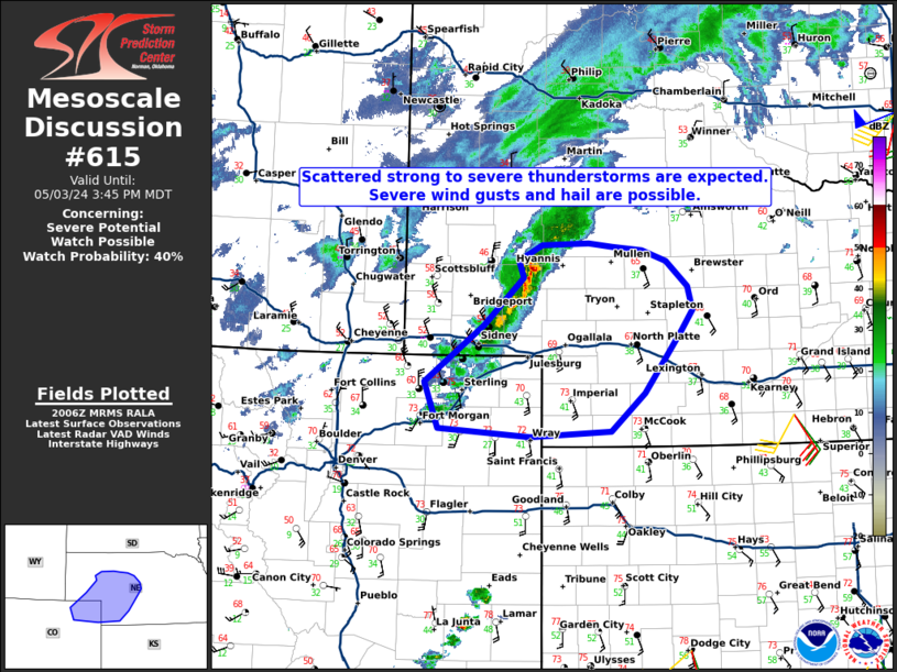
Mesoscale Discussion 0615
NWS Storm Prediction Center Norman OK
0309 PM CDT Fri May 03 2024

Areas affected...Far northeastern Colorado and western Nebraska

Concerning...Severe potential...Watch possible

Valid 032009Z - 032145Z

Probability of Watch Issuance...40 percent

SUMMARY...Scattered thunderstorms will continue to develop across
parts of western and northwestern Nebraska, and far northeastern
Colorado through this afternoon. Severe wind gusts of 55 to 70 mph
and large hail near 1.25 to 1.75 inches will be possible.

DISCUSSION...Latest surface observations and visible satellite
imagery indicate a cold front advancing southward across the
panhandle of Nebraska and into far northeastern Colorado. Strong
linear forcing along this front, along with increasing large scale
ascent above it via DCVA accompanying a mid to upper shortwave
trough, has resulted in thunderstorm development. The current
environment preceding the front is characterized by effective shear
magnitudes near 40 kt and MUCAPE near 1000 J/kg. Dewpoints well
ahead of the front across the high plains of eastern CO and west
central KS are in the low 50s, along with temperatures in the low to
mid 70s, where buoyancy is increasing under steep mid level lapse
rates around 8-8.5 C/km. This environment will continue to advance
northward with time ahead of the front with low-level moisture
advection. Therefore, expect an increase in organized severe
convection over the next 1-2 hours with a threat of large hail and
damaging winds.

..Barnes/Squitieri/Smith.. 05/03/2024

...Please see www.spc.noaa.gov for graphic product...

ATTN...WFO...GID...LBF...GLD...BOU...CYS...

LAT...LON   40110221 40190355 40700374 41330288 41850231 42050239
            42210205 42230137 42200102 42150058 42030023 41759992
            41509986 41270002 40900030 40580056 40160104 40110221
Read more